


Zevtt - My La Mothe St Héray

kipoura
Utilisateur
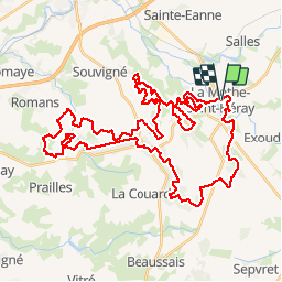

Longueur
54 km

Altitude max
199 m

Dénivelé positif
845 m
Km-Effort
66 km

Altitude min
74 m

Dénivelé négatif
849 m
Boucle
Oui
Date de création :
2019-05-03 17:10:40.394
Dernière modification :
2019-05-03 17:10:40.519
3h30
Difficulté : Difficile

Application GPS de randonnée GRATUITE
 SityTrail
IGN / Instituts géographiques
SityTrail Plus
Le monde est à vous
À propos
Randonnée V.T.T. de 54 km à découvrir à Nouvelle-Aquitaine, Deux-Sèvres, La Mothe-Saint-Héray. Cette randonnée est proposée par kipoura.
Description
Un trés beau parcours de VTT au départ de la Mothe St Héray. Un circuit physique, mais plein de plaisir .... http://zevtt.free.fr
Localisation
Pays :
France
Région :
Nouvelle-Aquitaine
Département/Province :
Deux-Sèvres
Commune :
La Mothe-Saint-Héray
Localité :
Unknown
Départ:(Dec)
Départ:(UTM)
722178 ; 5138170 (30T) N.
Commentaires